
Northeast Edmonton Homes For Sale
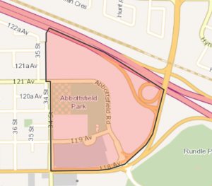 Click Image To View MLS® Listings in Abbotsfield, Edmonton |
Abbottsfield | SIGN UP HERE for AbbottsgfieldNeighbourhood News including new MLS® listings and sold statistics. | Map it | |
 Click Image To View MLS® Listings in Balwin, Edmonton |
Balwin | SIGN UP HERE for Balwin Neighbourhood News including new MLS® listings and sold statistics. | Balwin Previously part of North Edmonton, Balwin was annexed in 1912 and developed primarily in the 1940s and 50s. Most homes in the area are single-family dwellings, which are served by excellent school and park facilities as well as Londonderry Mall, one of the city’s largest. |
Map it |
 Click Image To View MLS® Listings in Bannerman, Edmonton |
Bannerman | SIGN UP HERE for Bannerman Neighbourhood News including new MLS® listings and sold statistics. | Bannerman Named for H. Bannerman, who settled in the Belmont area in 1883, this area is part of the Clareview district and was annexed to the City, along with much of northeast Edmonton, in the early 1960s. Easy LIGHT RAPID TRANSIT access to Edmonton’s commercial and employment areas, as well as excellent recreation and educational facilities in the heart of the neighbourhood, make Bannerman popular with young families. |
Map it |
|
Click Image To View MLS® Listings in Beacon Heights, Edmonton |
Beacon Heights | SIGN UP HERE for Beacon Heights Neighbourhood News including new MLS® listings and sold statistics. | Beacon Heights Beacon Heights was one neighbourhood that made up the area called Beverly. After 1910 rich coal seams were discovered and coal mining spurred development. In 1913 the area was incorporated as the Village of Beverly and in 1914 became a town. In 1961 Beverly amalgamated with the City of Edmonton to later be divided into neighbourhoods including Beacon Heights. The character of Beacon Heights comes from the combination of low and high density housing and the easy access to commercial routes and services. |
Map it |
 Click Image To View MLS® Listings in Belle Rive, Edmonton |
Belle Rive | SIGN UP HERE for Belle Rive Neighbourhood News including new MLS® listings and sold statistics. | Map it | |
 Click Image To View MLS® Listings in Bellevue, Edmonton |
Bellevue | SIGN UP HERE for Bellevue Neighbourhood News including new MLS® listings and sold statistics. | Bellevue One of the City’s smaller neighbourhoods, Bellevue was developed prior to 1950. Eastglen Composite High School, which serves students in much of east central Edmonton, is a dominant feature of the area (though a high proportion of area residents are over the age of 60 or retirees). Bellevue is highlighted by stunning views of the river valley and the city skyline. |
Map it |
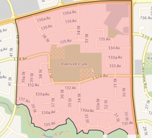 Click Image To View MLS® Listings in Belmont, Edmonton |
Belmont | SIGN UP HERE for Belmont Neighbourhood News including new MLS® listings and sold statistics. | Belmont Part of the Clareview district, Belmont traces its early development to 1912, though the bulk of its development took place in the 1970s. A mixture of single-family units and condominiums, the area’s excellent LIGHT RAPID TRANSIT service and efficient thoroughfares reflect efforts to maintain a quiet, family-friendly environment. Access to the river valley through Kennedale Ravine is a popular feature of the area, and attractive paths through the area encourage pedestrian and bicycle travel. |
Map it |
 Click Image To View MLS® Listings in Belvedere, Edmonton |
Belvedere | SIGN UP HERE for Belvedere Neighbourhood News including new MLS® listings and sold statistics. | Belvedere Once part of the village of North Edmonton, Belvedere contains the Fort Road, which first thrived at a time when the trek between Fort Saskatchewan and Edmonton was made by wagon. Until as late as 1964, Belvedere was considered the outskirts of northeastern Edmonton. Today the area contains a variety of housing styles, as well as the commercial and other non-residential land uses concentrated along the Fort Road. |
Map it |
 Click Image To View MLS® Listings in Bergman, Edmonton |
Bergman | SIGN UP HERE for Bergman Neighbourhood News including new MLS® listings and sold statistics. | Bergman Bergman was one neighbourhood that made up the area called Beverly. After 1910 rich coal seams were discovered and coal mining spurred development. In 1913 the area was incorporated as the Village of Beverly and in 1914 became a town. In 1961 Beverly amalgamated with the City of Edmonton to later be divided into neighbourhoods including Bergman. Character of Bergman is created from two distinct periods of construction; one very grid like, and the other curvilinear with cul de sac street patterns creating a very unique neighbourhood. |
Map it |
 Click Image To View MLS® Listings in Beverly Heights, Edmonton |
Beverly Heights | SIGN UP HERE for Beverly Heights Neighbourhood News including new MLS® listings and sold statistics. | Beverly Heights Beverly Heights is name from the Town of Beverly in Yorkshire England. Beginnning as a small mining community in 1882 the village was incorporated as a town in 1914 and was amalgamated in 1961 with the City of Edmonton. In 1953 the Beverly Bridge opened linking main street (118 Avenue) with Highway 16. The northern portion of the former Town of Beverly contains the neighbourhoods of Beacon Heights and Bergman, the southern portion is know as Beverly Heights. The mature tree lined streets provide character to the neighbourhood. |
Map it |
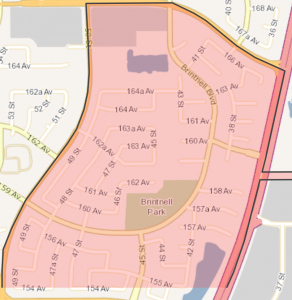 Click Image To View MLS® Listings in Brintnell, Edmonton |
Brintnell | SIGN UP HERE for Brintnell Neighbourhood News including new MLS® listings and sold statistics. | Brintnell The neighbourhood was named in honour of Wilfred Leigh Brintnell a pilot, who was well known for his pioneering trips across uncharted areas. Brintnell today (2010) is surrounded by residential neighbourhoods to the south and west, and Gorman Industrial is located to the east across Manning Drive. 94% of housing units are single-family residences. Brintnell’s circulation design features arterial roadways along the exterior of the neighbourhood, with a loops and cul-de-sacs design on the interior. A powerline right-of-way provides a green corridor and pedestrian pathway for residents. |
Map it |
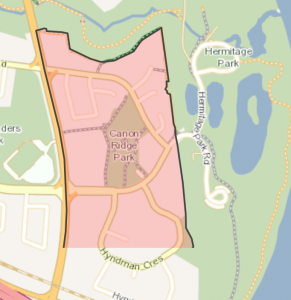 Click Image To View MLS® Listings in Canon Ridge, Edmonton |
Canon Ridge | SIGN UP HERE for Canon Ridge Neighbourhood News including new MLS® listings and sold statistics. | Canon Ridge Canon Ridge lies within the Hermitage area, and is named for an Anglican minister who arrived in Edmonton in 1875. The area had two cattle farms until as late as 1960, when it was annexed by the City. Most housing was built in the 1980s on attractive curving streets and cul-de-sacs. The area contains appealing recreational spaces, as well as excellent access to river valley parks. |
Map it |
 Click Image To View MLS® Listings in Casselman, Edmonton |
Casselman | SIGN UP HERE for Casselman Neighbourhood News including new MLS® listings and sold statistics. | Casselman Named for Frederick. C. Casselman, who practised law in Edmonton in the early part of the 20th century, this northeast neighbourhood consists of a blend of single-family homes and multi-unit dwellings, as well as substantial recreation spaces and appealing pedestrian pathways throughout the neighbourhood. Although there are no schools in Casselman, two elementary and two junior high schools are conveniently located in nearby McLeod. |
Map it |
 Click Image To View MLS® Listings in Clareview Town Centre, Edmonton |
Clareview Town Centre | SIGN UP HERE for Clareview Town Centre Neighbourhood News including new MLS® listings and sold statistics. | Map it | |
 Click Image To View MLS® Listings in Cromdale, Edmonton |
Cromdale | SIGN UP HERE for Cromdale Neighbourhood News including new MLS® listings and sold statistics. | Cromdale One of Edmonton’s older inner-city neighbourhoods, Cromdale lies just to the northeast of the City centre. Once a low-density residential area, Cromdale was redeveloped in the 1960s to include more apartment buildings. The area has a mobile and youthful population. Kinnaird Ravine, which winds its way through the neighbourhood, offers excellent recreational opportunities for area residents. |
Map it |
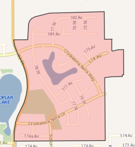 Click Image To View MLS® Listings in Crystallina Nera, Edmonton |
Crystallina Nera | SIGN UP HERE for Crystallina Nera Neighbourhood News including new MLS® listings and sold statistics. | Map it | |
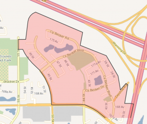 Click Image To View MLS® Listings in Cy Becker, Edmonton |
Cy Becker | SIGN UP HERE for Cy Becker Neighbourhood News including new MLS® listings and sold statistics. | Map it | |
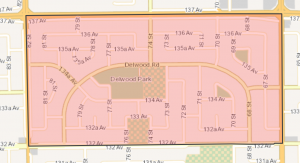 Click Image To View MLS® Listings in Delwood, Edmonton |
Delwood | SIGN UP HERE for Delwood Neighbourhood News including new MLS® listings and sold statistics. | Delwood Delwood is a mature, stable suburban neighbourhood featuring 90% single detached homes. The design of the neighbourhood is typical for the 1960s, following a modified grid pattern and several small island parks. The schools are centrally located, and commercial land uses are situated at the corners of the neighbourhood. |
Map it |
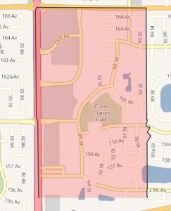 Click Image To View MLS® Listings in Eaux Claires, Edmonton |
Eaux Claires | SIGN UP HERE for Eaux Claires Neighbourhood News including new MLS® listings and sold statistics. | Eaux Claires Eaux Claries takes its name from a body of water, and the neighbourhood name means “clear waters” in French. Residential construction began in the late 1990s and was still underway as of 2010. The road system enables easy access to the neighbourhood. Pedestrian pathways and linkages are included throughout the neighbourhood. The neighbourhood also includes a central park/school site in addition to other small parks and storm water management ponds. A playground and park development is in the process of happening in 2010. |
Map it |
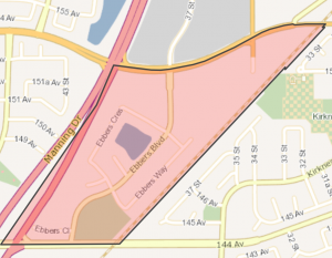 Click Image To View MLS® Listings in Ebbers, Edmonton |
Ebbers | SIGN UP HERE for Ebbers Neighbourhood News including new MLS® listings and sold statistics. | Map it | |
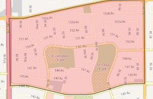 Click Image To View MLS® Listings in Evansdale, Edmonton |
Evansdale | SIGN UP HERE for Evansdale Neighbourhood News including new MLS® listings and sold statistics. | Evansdale Evansdale is named for H.M.E. Evans, Mayor of Edmonton in 1918. Mr. Evans was also president of the Edmonton Board of Trade in 1916. Although single detached homes account for 90% of the structures in Evansdale, almost 50% of the dwelling units are located in multi unit housing and low-rise apartments. Residents enjoy two elementary schools, a junior high school, two churches and a community league. |
Map it |
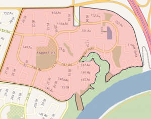 Click Image To View MLS® Listings in Fraser, Edmonton |
Fraser | SIGN UP HERE for Fraser Neighbourhood News including new MLS® listings and sold statistics. | Fraser Named for John Fraser, an original homesteader in the area and one of the first trustees of the Belmont School, Fraser is located in the City’s far northwest. Part of Clareview, it was developed during the 1980s. A young community, Fraser is highlighted by a multiple school and recreation area as well as a small shopping centre. |
Map it |
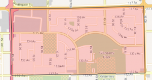 Click Image To View MLS® Listings in Glengarry, Edmonton |
Glengarry | SIGN UP HERE for Glengarry Neighbourhood News including new MLS® listings and sold statistics. | Glengarry Glengarry is a diverse mix of commercial, residential, institutional and recreational land uses. Northwood Mall provides excellent retail and service facilities, and the area also features schools, parkland and a swimming pool. |
Map it |
 Click Image To View MLS® Listings in Gorman, Edmonton |
Gorman | SIGN UP HERE for Gorman Neighbourhood News including new MLS® listings and sold statistics. | Map it | |
 Click Image To View MLS® Listings in Hairsine, Edmonton |
Hairsine | SIGN UP HERE for Hairsine Neighbourhood News including new MLS® listings and sold statistics. | Hairsine Hairsine was named for the first mayor of the town of Beverly and includes the Victoria Trail, which once led to the Old Victoria Settlement. Developed in the 1970s and 80s as part of Clareview, it is dominated by row housing and low-rise apartments. The LIGHT RAPID TRANSIT offers excellent access to other parts of the City for the area’s mostly young adult residents. |
Map it |
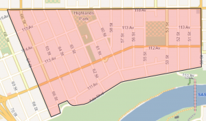 Click Image To View MLS® Listings in Highlands, Edmonton |
Highlands | SIGN UP HERE for Highlands Neighbourhood News including new MLS® listings and sold statistics. | Highlands Highlands, annexed to the city in 1912, was named in a contest offering a 50-dollar prize. In 1911, real estate developers McGrath and Holgate built their mansions on Ada Boulevard (which was named after McGrath’s wife). Other large, well-appointed houses were built nearby, where residents enjoy a spectacular view of the North Saskatchewan River Valley. More modest housing is located further from the valley. |
Map it |
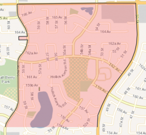 Click Image To View MLS® Listings in Callaghan, Edmonton |
Hollick-Kenyon | SIGN UP HERE for Hollick-Kenyon Neighbourhood News including new MLS® listings and sold statistics. | Hollick-Kenyon The neighbourhood was named after Herbert “Bertie” Hollick-Kenyon, who piloted flights over the Antarctic as part of the first mapping of that territory. Residential construction in the neighbourhood began in the early 1990s. A school/pack site is located in the middle of the neighbourhood with developed fields and a new school. A storm water lake located in the south-west and pipeline corridor provides residents with access to open space along with a series of pathways providing pedestrian connections between residential and parks areas. |
Map it |
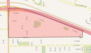
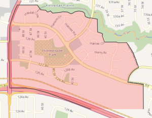 Click Image To View MLS® Listings in Homesteader, Edmonton |
Homesteader | SIGN UP HERE for Homesteader Neighbourhood News including new MLS® listings and sold statistics. | Homesteader Named for Anglican minister William Newton, Homesteader features a multi-purpose education and recreation site in the centre of the neighbourhood. A number of strategically placed pathways promote bicycle and pedestrian travel within the neighbourhood. Homesteader residents have access to the river valley park system via Kennedale Ravine. |
Map it |
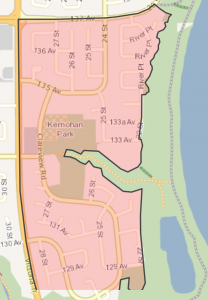 Click Image To View MLS® Listings in Kernohan, Edmonton |
Kernohan | SIGN UP HERE for Kernohan Neighbourhood News including new MLS® listings and sold statistics. | Kernohan Named for an early pioneer farmer who operated a grocery store here in the 1880s and 90s, Kernohan was not annexed until 1961. Part of Clareview, it saw the bulk of its development take place during the 1960s oil-driven economic boom. Kernohan is bounded by Kennedale Ravine and the river valley, both popular features with the area’s high proportion of young families. |
Map it |
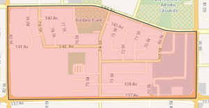 Click Image To View MLS® Listings in Kildare, Edmonton |
Kildare | SIGN UP HERE for Kildare Neighbourhood News including new MLS® listings and sold statistics. | Kildare Kildare, in the City’s northeast, is named for an Irish county. The area has a fairly even mix of residential and commercial/institutional land uses, and is dominated by Londonderry Mall and St. Michael’s Cemetery. Kildare has a stable population, with a high proportion of young families, as well as a significant number of seniors served by an extended care facility in the area. |
Map it |
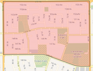 Click Image To View MLS® Listings in Kilkenny, Edmonton |
Kilkenny | SIGN UP HERE for Kilkenny Neighbourhood News including new MLS® listings and sold statistics. | Kilkenny Kilkenny lies to the City’s far north, snuggled up against farms and forest. Dominated by Single-family homes, Kilkenny also features low-rise apartment buildings and row housing. The neighbourhood enjoys five schools and a sports/recreation complex popular with the many school age children living in the area. |
Map it |
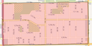 Click Image To View MLS® Listings in Killarney, Edmonton |
Killarney | SIGN UP HERE for Killarney Neighbourhood News including new MLS® listings and sold statistics. | Killarney Part of the City since 1913, much of this neighbourhood was developed in the 1960s. The area, which features over 80 businesses, has a high proportion of residents between 50 and 69 years old. A subdivision and elementary school in the area are named MeeYah Noh, derived from the Cree, meaning “a good place to be”. |
Map it |
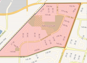 Click Image To View MLS® Listings in Kirkness, Edmonton |
Kirkness | SIGN UP HERE for Kirkness Neighbourhood News including new MLS® listings and sold statistics. | Kirkness Located in the Clareview district, this area is named for James Kirkness, a Hudson’s Bay Company employee who came here from Scotland in 1866. A local park is named for James A. Christianson (1889-1953), a prominent citizen who sponsored the Oil Kings hockey club. Dominated by single-family homes, Kirkness has a young population. Kirkness is well served by the Light Rapid Transit. |
Map it |
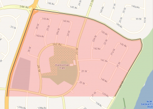
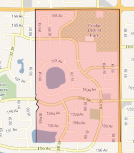
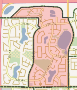 Click Image To View MLS® Listings in Klarvatten |
Klarvatten | SIGN UP HERE for Klarvatten Neighbourhood News including new MLS® listings and sold statistics. | Klarvatten Klarvatten is Swedish for “clear water”. The neighbourhood began to first experience residential construction in the late 1980s, but over 50% of residential construction took place in the 2000s. One of the major features of the neighbourhood is a large storm water lake and wetland-Poplar lake located in the east-central part. The storm water lake provides residents with access to an attractive outdoor amenity and provides some recreation space within the community. The neighbourhood also features several parts, connected via pedestrian pathways. |
Map it |
 Click Image To View MLS® Listings in Lago Lindo, Edmonton |
Lago Lindo | SIGN UP HERE for Lago Lindo Neighbourhood News including new MLS® listings and sold statistics. | Lago Lindo Named to reflect Edmonton’s ethnic diversity, Lago Lindo is Spanish for”pretty lake”, and contains two lakes named for communities in Spain. Educational and recreational facilities lie in the heart of the district, and attractive pathways promote pedestrian and bicycle travel throughout Lago Lindo. This is a stable, primarily residential area developed in the 1980s |
Map it |
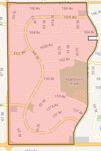 Click Image To View MLS® Listings in Matt Berry, Edmonton |
Matt Berry | SIGN UP HERE for Matt Berry Neighbourhood News including new MLS® listings and sold statistics. | Matt Berry Matt Berry was named in honour of a Canadian aviation pioneer. Massey “Matt” Berry a veteran of both world wars and bush pilot.Matt Berry is almost entirely residential and was planned to accommodate primarily single-family houses. The neighbourhoods began to experience some development in the 1980’s but the bulk of construction took place in the 1900’s and continued into the 2000s.Pipeline right-of-ways running east-west and in the southeast corner provide pedestrian and cyclist connections. A large school/park site is located on the eastern boundary of the neighbourhood with a playground, school and smaller parks are strategically within the neighbourhood to provide residents with public amenity space. |
Map it |
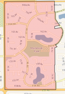 Click Image To View MLS® Listings in Mayliewan, Edmonton |
Mayliewan | SIGN UP HERE for Mayliewan Neighbourhood News including new MLS® listings and sold statistics. | Mayliewan Mayliewan, named after a body of water was taken from the Cantonese word meaning “beautiful day”. Development began in the 1980s with the bulk of construction taking place in the 1990s and 2000’s. Residents have easy access to parks and two stormwater lakes. A large school/park site is located in the centre of the neighbourhood and houses St. John Bosco Elementary School and a children playground. A pipeline right-of-way runs diagonally across Mayliewan which is a key linking feature within pedestrian pathway network. |
Map it |
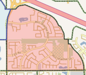 Click Image To View MLS® Listings in McConachie, Edmonton |
Mcconachie Area | SIGN UP HERE for McConachie Neighbourhood News including new MLS® listings and sold statistics. | Map it | |
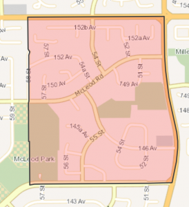
 Click Image To View MLS® Listings in McLeod, Edmonton |
Mcleod | SIGN UP HERE for Mcleod Neighbourhood News including new MLS® listings and sold statistics. | McLeod Unique to McLeod is the fact that almost all of its residential properties are developed with single detached dwellings. Most of these were built during the 1960s. Streets are laid out in crescents and cul-de-sacs and its residential lots are large. |
Map it |
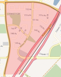 Click Image To View MLS® Listings in Miller, Edmonton |
Miller | SIGN UP HERE for Miller Neighbourhood News including new MLS® listings and sold statistics. | Miller Miller was named after Abe William Miller, a Hungarian-born lawyer, politician and community volunteer. The nearby Clareview Light Rail Transit (LRT) station provides residents with good transit access. Two pipeline rights-of-way cross the neighbourhood and their surfaces have been integrated with the pedestrian transportation network of the community. The park site located in the west-central area of the neighbourhood provides sports fields and a playground. Additionally, a one hectare naturalized wetland park provides natural amenity space. The neighbourhood began development in the 1990¿s and finished in early 2000. |
Map it |
 Click Image To View MLS® Listings in Montrose, Edmonton |
Montrose_Edmonton | SIGN UP HERE for Montrose Neighbourhood News including new MLS® listings and sold statistics. | Montrose Most of Montrose was developed prior to 1950, and the remainder completed before 1960. On residential land, most homes are single and semi-detached. Multi-family structures are located adjacent to the major roadways. Industrial and commercial land is concentrated in the western portion of the neighbourhood. Residents enjoy good access the Light Rail Transit system and Skyreach Centre. |
Map it |
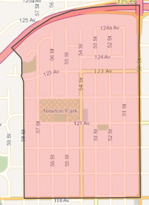 Click Image To View MLS® Listings in Newton, Edmonton |
Newton | SIGN UP HERE for Newton Neighbourhood News including new MLS® listings and sold statistics. | Newton Newton for Reverend William Newton, (who arrived in Edmonton in 1875), Newton’s development has been spread out over several decades. The portion north of 123 Avenue was annexed along with the town of North Edmonton in 1912 and southern Newton joined Edmonton a year later. While southern Newton contains residences built before World War II, the northwest corner of the neighbourhood is the site of very recent development activity. |
Map it |
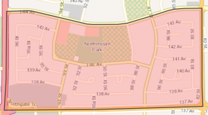 Click Image To View MLS® Listings in Northmount, Edmonton |
Northmount | SIGN UP HERE for Northmount Neighbourhood News including new MLS® listings and sold statistics. | Northmount Residential land accounts for almost 70 percent of Northmount. Most homes were built during the late 1960s and early 1970s. The dominant structure type is the single detached house. Residents enjoy access to three schools, community league facilities and an auxiliary hospital as well as North Town Mall. |
Map it |
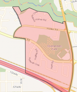 Click Image To View MLS® Listings in Overlanders, Edmonton |
Overlanders | SIGN UP HERE for Overlanders Neighbourhood News including new MLS® listings and sold statistics. | Overlanders In 1875 an Anglican minister built a church, home and hospital which he called the Hermitage, a name which is now used to describe the three neighbourhoods in this area. Much of the land was agricultural until 1960 when Overlanders and the other two Hermitage neighbourhoods were subdivided. Development began in the late 1970s, a mixture of single-family homes, row housing and apartment buildngs on a curving street system. Residents, many of them young families, have easy access to river valley parks. |
Map it |
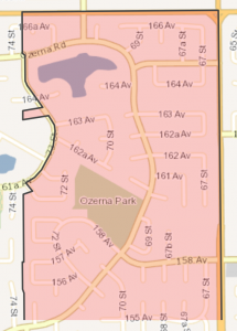 Click Image To View MLS® Listings in Ozerna, Edmonton |
Ozerna | SIGN UP HERE for Ozerna Neighbourhood News including new MLS® listings and sold statistics. | Ozerna Ozerna is a Ukrainian word that means “lake area”. Construction began in the 1980s and continued on well into the 2000s. Features include a central school and park site within walking distance, for all residents. As of 2009 a school had not yet been developed but the park site with developed sports field and a playground interconnect the community. A storm water management lake and linear park, that runs on top of the powerline right-of-way and provides more open space (80%) and connections. |
Map it |
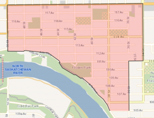
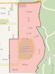 Click Image To View MLS® Listings in Rundle Heights, Edmonton |
Rundle Heights | SIGN UP HERE for Rundle Heights Neighbourhood News including new MLS® listings and sold statistics. | Rundle Heights While Rundle Heights was first settled in the 1880s and was annexed to the City in 1961, most development did not occur until the 1970s. Named for the City’s first Protestant missionary, it features Rundle Park, a popular and attractive educational and recreational space. |
Map it |
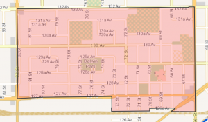
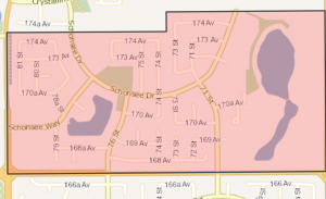 Click Image To View MLS® Listings in Schonsee, Edmonton |
Schonsee | SIGN UP HERE for Schonsee Neighbourhood News including new MLS® listings and sold statistics. | Schonsee The name Schonsee is derived from the German word “schon”, meaning beautiful, and “see” meaning lake. The plan for the neighbourhood is to develop a primarily residential community with a variety of housing options. The projected population is over 3,000 residents, and a student generation of just under 400 school-aged children. A 1.8 hectare park is located north of the storm water lake, and a smaller hectare park is located on the northeast shore of the lake. These amenities will provide residents with outdoor recreation space. |
Map it |
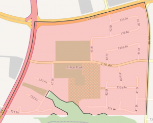 Click Image To View MLS® Listings in Sifton Park, Edmonton |
Sifton Park | SIGN UP HERE for Sifton Park Neighbourhood News including new MLS® listings and sold statistics. | Sifton Park Sifton Park was named after the Honourable Arthur R. Sifton the Premier of Alberta from 1910 to 1917. First subdivided in 1912 it began to really develop in 1972 to 1979. Sifton Park is bound by 3 major roadways. An LRT terminal provides excellent access to commercial and employment areas. Kennedale ravine provides residents with easy access to the river valley park system on the south. In addition the education centre is central and strategically placed trails and paths promote pedestrian and bike traffic throughout the neighbourhood. |
Map it |
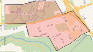 Click Image To View MLS® Listings in Virginia Park, Edmonton |
Virginia Park | SIGN UP HERE for Virginia Park Neighbourhood News including new MLS® listings and sold statistics. | Virginia Park Virginia Park was one of many areas subdivided during the land boom prior to World War I – but it developed slowly, even though the Highlands streetcar line passed through the neighbourhood. Over 80% of all structures were built before 1950. The neighbourhood contains two prominent landmarks, Concordia College and Borden Park, and the river valley is accessible directly to the south. |
Map it |
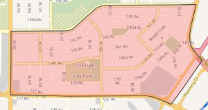 Click Image To View MLS® Listings in York, Edmonton |
York | SIGN UP HERE for York Neighbourhood News including new MLS® listings and sold statistics. | York York is somewhat of a ‘pioneer’ neighbourhood. In 1967 row housing units in Edmonton’s first condominium complex were offered for sale in the neighbourhood. During the population boom of the 1960s, developers could not build single homes fast enough to meet demand, and concerns about urban sprawl were paramount. |
Map it |

